$10 per GB • No subscription • Use code DRONEFTP10 for $10 off your first project
Drone Photogrammetry Processing
Cloud Photogrammetry Processing for Drone Mapping Projects
Upload customer-supplied drone imagery and let DroneFTP handle the computational processing.
DroneFTP provides pay-as-you-go cloud photogrammetry processing for drone pilots, GIS professionals, environmental consultants, construction teams, mapping professionals, and other users who need photogrammetric outputs without tying up a local workstation for hours or days.
Upload your imagery, select your processing options, and receive completed geospatial outputs through the cloud.
$10 per GB. No monthly subscription. No dedicated processing computer required.
New users can use promo code DRONEFTP10 for $10 off their first project.
What DroneFTP Produces
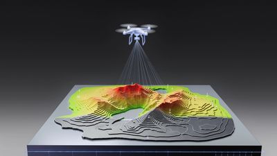
DroneFTP processes customer-supplied drone imagery into commonly used photogrammetric data products, including:
- Orthomosaic GeoTIFFs
- Digital Elevation Models (DEMs)
- Digital Surface Models (DSMs)
- Digital Terrain Models (DTMs)
- DXF contour data
- LAZ point-cloud files
- Georeferenced mapping outputs
Outputs are provided in formats compatible with common GIS and CAD workflows.

How Cloud Photogrammetry Processing Works
Drone photogrammetry can require substantial CPU, GPU, memory, storage, and processing time—especially when projects contain hundreds or thousands of high-resolution images.
DroneFTP moves that computational workload to cloud infrastructure instead of requiring every project to be processed on a local workstation.
The workflow is straightforward:
- Upload your drone imagery.
- Select the processing options needed for your project.
- DroneFTP processes the imagery remotely.
- Download the completed photogrammetric outputs.
This allows users to add processing capacity without purchasing another high-end workstation or committing to another recurring photogrammetry software subscription.
Orthomosaic Processing
Orthomosaics combine overlapping aerial photographs into a georeferenced raster image.
DroneFTP can generate orthomosaic GeoTIFFs from properly collected customer imagery for use in mapping, visualization, monitoring, environmental review, construction documentation, and compatible GIS workflows.
Output quality depends on the source imagery, flight geometry, overlap, positioning information, collection conditions, and processing parameters.
DEM, DSM and DTM Processing
DroneFTP can generate elevation surfaces from photogrammetric reconstruction.
DEM — Digital Elevation Model
A raster representation of elevation derived from the processed dataset.
DSM — Digital Surface Model
An elevation surface that may include buildings, vegetation, and other above-ground features.
DTM — Digital Terrain Model
An estimated bare-earth elevation surface generated through point classification and processing.
These outputs can be used for visualization, preliminary terrain evaluation, data review, and downstream professional workflows as appropriate.
Contours and Point Clouds
DroneFTP can also generate:
DXF Contours
Photogrammetrically derived contour data delivered in DXF format for use in compatible GIS and CAD software.
LAZ Point Clouds
Compressed three-dimensional point-cloud data that can be viewed and analyzed in compatible geospatial software.
Processing Large Drone Mapping Datasets
Large drone mapping projects can quickly exceed the comfortable processing limits of ordinary computers.
As image count and resolution increase, photogrammetry may require more:
- RAM
- GPU resources
- CPU capacity
- Fast storage
- Temporary disk space
- Processing time
Cloud processing can provide additional capacity when internal computers are already occupied or when purchasing another dedicated processing workstation does not make economic sense.
Learn more about processing drone data without a powerful computer and handling larger drone mapping datasets in the DroneFTP Resources section.
Cloud vs. Desktop Photogrammetry Processing
Desktop photogrammetry software provides direct control over processing settings and can make sense for organizations processing imagery continuously.
Cloud processing can make more sense when:
- Project volume varies
- Internal computers are already busy
- A business does not want another recurring software subscription
- A dataset is larger than normal
- Additional processing capacity is temporarily needed
- A user wants straightforward generation of common photogrammetric outputs
The two approaches can also be used together. Cloud processing can serve as overflow capacity when local resources are occupied.
Pay-As-You-Go Photogrammetry Pricing
DroneFTP photogrammetry processing costs $10 per GB of uploaded imagery, with a $10 minimum per project.
Examples:
- 1 GB upload — $10
- 3 GB upload — $30
- 5 GB upload — $50
- 10 GB upload — $100
- 15 GB upload — $150
There is no monthly photogrammetry-processing subscription.
New users can use promo code DRONEFTP10 for $10 off their first project.
What Makes a Good Photogrammetry Dataset?
Photogrammetry results depend heavily on how the imagery was collected.
Datasets generally benefit from:
- Consistent flight altitude
- Sufficient front and side overlap
- Sharp, properly exposed images
- Nadir-oriented imagery for standard mapping workflows
- Consistent coverage across the project area
- Reliable image positioning data
More images are not always better. Excessive overlap can increase upload size and processing requirements without necessarily providing a proportional improvement in results.
Accuracy and Ground Control
Photogrammetric output quality and positional accuracy depend on several factors, including source imagery, flight geometry, positioning information, overlap, image quality, collection method, and processing conditions.
DroneFTP currently processes customer-supplied data and does not certify survey accuracy or provide professional land-surveying or engineering services.
Users are responsible for determining whether outputs are suitable for their intended application and for obtaining review or certification by an appropriately licensed professional when required.
Frequently Asked Questions
Do I need a powerful computer to use DroneFTP?
No dedicated photogrammetry workstation is required. Imagery is uploaded for cloud processing, allowing the computational workload to run remotely.
How much does DroneFTP cost?
Photogrammetry processing is $10 per GB of uploaded imagery, with a $10 minimum per project.
Is there a subscription?
No. DroneFTP uses pay-as-you-go pricing rather than a monthly photogrammetry-processing subscription.
What files can DroneFTP produce?
Available outputs can include orthomosaic GeoTIFFs, DEMs, DSMs, DTMs, DXF contours, and LAZ point clouds.
Can DroneFTP process large datasets?
Cloud processing can be useful for larger projects that may require substantial local CPU, GPU, RAM, storage, or processing time. Practical processing limits depend on the dataset and workflow.
Does DroneFTP provide survey-grade or engineering-certified outputs?
No. DroneFTP provides automated data-processing services only and does not provide professional engineering or land-surveying services or certify project accuracy.
Professional Services Disclaimer: DroneFTP provides automated data-processing services only and does not provide professional engineering or land-surveying services. Outputs are generated from customer-supplied data, are not certified survey or engineering products, and should be reviewed by an appropriately licensed professional when required for the intended use.